An ultrarunning day on the Fimmvörðuháls Trail - Skógar to Thórsmörk, Iceland
The reason I started to write about my runs was to inspire others to find a new trail, travel somewhere that might have seemed scary or challenge themselves with a new adventure. If just one person finds inspiration from my posts and does something they’ve never done before then I’ll feel satisfied. Occasionally, I also get to share first hand with friends why I like to go on these trips. On a recent trip to Iceland, a friend of mine, Daniel, came along for the trip. Daniel has been on a couple running trips with me before, but he didn’t stay with me for the full distance since he does not train for running like I do. However, on this trip, since I planned an out-and-back, it’d be easier for him to stay with me, and if things got rough for any reason, we could just reverse course and head back. On this day, Daniel got to experience the full joy of ultrarunning that comes from seeing dramatic changes in scenery and the physical challenge from covering nearly 50k and 6000 feet (2000m) of elevation gain in a single run. There was a point where he wasn’t sure he’d be able to re-ascend the mountain we crossed, but by working together, and applying the ultramarthon principles of:
relentless forward progress
optimism that things will get better
staying hydrated and fueled
he succeeded finishing his first ultramarathon distance run!
I had to book this trip for early June because of my business travel schedule. While researching the Fimmvörðuháls and Landmannalaugar trails I found a few references that mentioned they might not be passable in June. While I would have liked to start in Landmannalaugar and run all the way to Skógar, I opted for an out-and-back starting from Skógar since I knew I’d still be able to get in a good run in the lower elevations, and if the conditions or weather turned bad, then I could just turn around. In addition, the hotel I booked, Hotel Skógafoss is only 30 minutes from a black sand beach I wanted to visit. And finally, while I normally travel with few things, on this trip I’d be flying from Berlin to Stockholm so had all my luggage, which meant it’d be easier to stay in one place for the trip.
We started north from Hotel Skógafoss at 10am along an alternate trail from the main trail that leads from the waterfall since I’d planned for a course that while mostly an out-and-back, would take different trails each way. The hotel had a nice buffet breakfast, but they had all I needed to get started, coffee, white bread, and Nutella. The trail started out as a rocky road, but in many places a trail in soft grass went along the berm and the trail occasionally cut across grass fields between the curves in the road. As we wound our way up the mountain which is almost an unbroken climb to 3700 feet (1127m), we appreciated the views of the ocean to our back, green mountains to our side and snow-capped mountains in front of us. We could even see all the way to the arch at Dyrhólaey near the black beaches we visited the evening before.
It wasn’t too long until the trail paralleled a valley to our right that was cut deeply by a stream. We took a lot of time making our way up the mountain stopping frequently to appreciate the scenery since there were so many waterfalls to see. The first major milestone is where the two trails converge at a bridge and we crossed the main river that supplies the Skógafoss Waterfall. We took a break and changed into our windbreakers because the wind was too much to take in just a t-shirt and shorts. A large group had also just started hiking north as we arrived. They were the first people we saw since most people head up the main trail accessed from the stairs next to the waterfall rather than the alternate trail we took.
We continued onward, and the trail paralleled another much deeper river valley that was even more impressive than the first. Snow and a greater volume of water filled this valley. It also was more clear which mountains we were ascending, and we could tell there would be snow at the top. The trail this entire way, while rocky, was runnable, but we fast hiked most of it because of the incline.
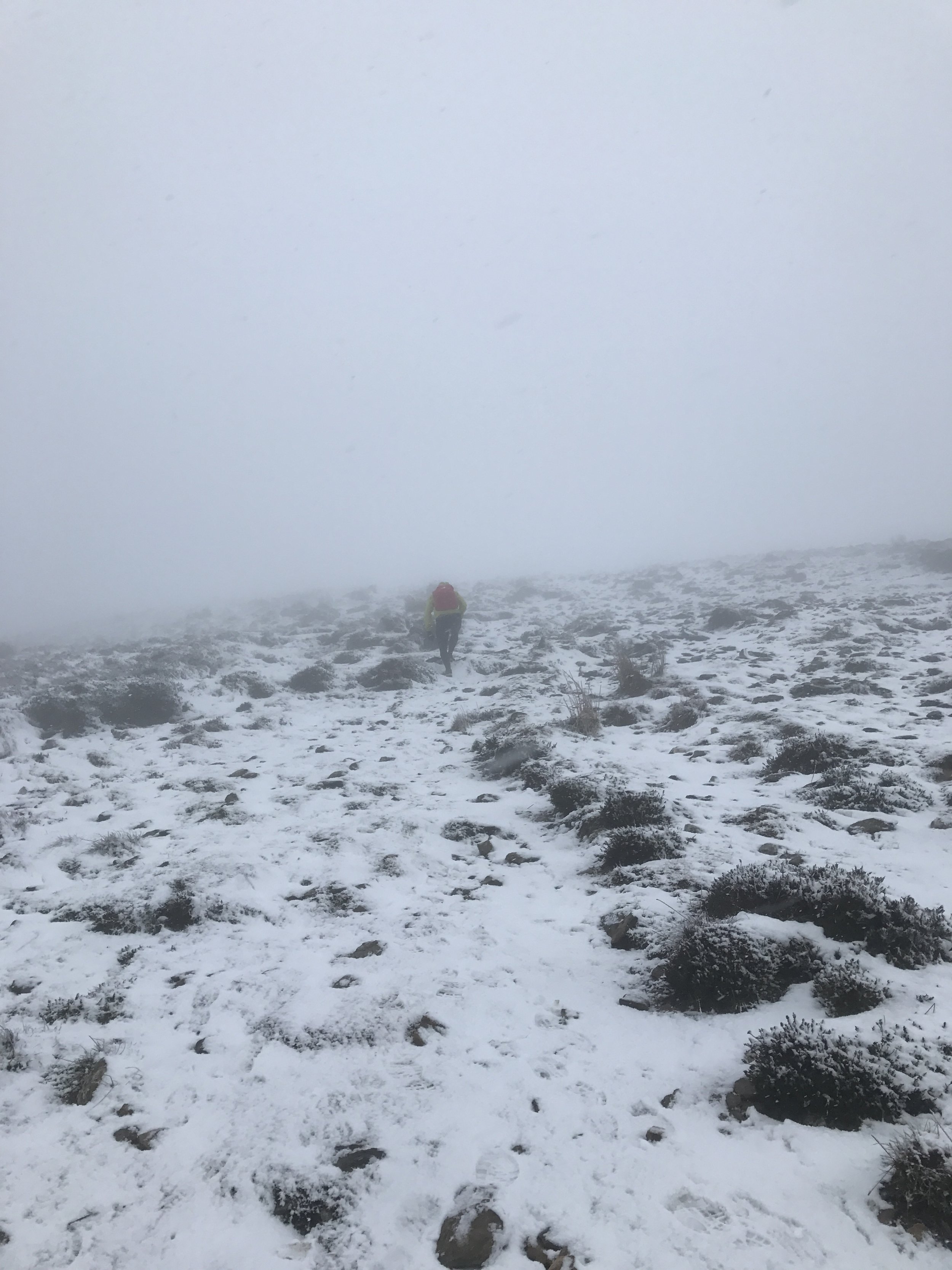
As the trail continued north, the temperature continued to drop, and the wind remained steady at 20-30km per hour. The landscape also became more volcanic, the amount of vegetation dropped and snow drifts were now common to the sides, but the trail remained dry. We got to the Baldvinsskáli Hut and took a break since there is a bathroom and a place to sit. After our break we continued north, and this is where the terrain dramatically changed.
Just 100 yards (100m) north of the hut we entered the first of many snowfields we had to cross. The trail cut straight north and dipped into and out of valleys filled with snow. Fortunately, we only sunk in a few inches with each step, so the snow was still runnable, and even possible to slide down the descents a short distance. One of the cool sites along the snow fields worth a small detour is the highest point of the hike, the Magni Crater, caused by the Fimmvörðuháls eruption in 2010.
After a few more snow fields to the north we crested a ridge, and that was where what seemed like the whole of Iceland opened up in front of us. In this one view one can appreciate the massive scale of it all and as we descended to Thórsmörk (Þórsmörk) we saw many waterfalls in the distance, large glaciers of many shapes and sizes, and a massive plateau that is the gateway to the lower valley below. To get to that plateau required descending a steep snowfield and then traverse across a ridge that is one of the most scary traverses I’ve made. I wish I had read about this section first since there is a chain that descends a short chute to the left of the trail, but the chain didn’t look well maintained. Because of how it looked I thought there must be a better way. I followed the path straight ahead another 10 yards (10m) and looked over the edge. The way to the left looked passable but to the right it was straight down several hundred meters. On the route to the left there is also a small stone archway that looked like I could fit through. The scary part was that if you slid to the right, it would not be good as there was a long drop. I decided to go for it, made it through the archway and shimmied to the bottom. Once on stable ground, I could look back to where the chain crossed and yelled up to Daniel it was the much better way to go. Definitely take the chain, it is the safer way to go!
From here we crossed the massive plateau that wasn’t as flat as it looked from far above, and then the trail got much steeper as we descended almost the full elevation over the next 3 miles (5k) to Thórsmörk. I originally planned on looping back on another trail from this point, but asked a tour guide we saw how the other trail was and he recommended not to go back that way as it might not be open. Given it was late in the day, and would get colder, I didn’t want to risk having to turn back and making two ascents. We turned around and went back the way we came, which meant we also had to cross back over the second scariest part of the trail a second time. There is a 50 yard (50m) narrow ridge with steep drop offs on both sides. You definitely want to stay very focused and have a stable footing in this area as there is no room for mistakes.
From here we ascended all the way back to the top then back down to the trail crossing with the bridge. The ascent is very steep, without switch backs, so it’s a great workout getting back up to the plateau. The snow fields were much more difficult on the second go around and our feet were getting cold since we were not moving so fast. At the trail crossing we stayed to the right to take the main trail back to Skógar.
While the day was filled with more waterfalls than we could remember and some of the most epic views I’ve seen while hiking, we were not prepared for what we’d see next. The trail parallels a deep value that has the views of the best waterfalls of the day and then farther down deep canyons covered with green moss. Because there was so much to see every couple hundred yards we were not quick coming down. The trail is very runnable, mostly hard packed dirt, grassy / mossy in places and infrequently with rock fields we walked to avoid an ankle turn. Two of the waterfalls were my favorites of the day.
We got back to the hotel around 9pm which meant we could still order dinner and enjoy a view of the Skógafoss Waterfall while eating (sundown wasn’t until midnight!). The Icelandic beer, chilled to a low temperature, also tasted great after a day of Twix Bars and gummy candies.
We went to bed just after dinner since we planned to get up at 6am to make the drive to the Blue Lagoon in the morning, a 2.5 hour drive. Be sure to make a reservation there as they get booked full since its one of the most popular places in Iceland to visit! We made a reservation at 9am so we’d have plenty of time to relax in the warm waters and also have lunch when the restaurant opened at noon (also make a reservation). The spa waters were not too hot, but if you stayed by one area where the water flowed in you can get a brief period of much hotter water. It’s also amusing there since you get self-service face masks. You can pick the type from silica, algae, volcanic and more, then have a drink while everyone is sitting around in the pool with a different color mask on their face. The restaurant was excellent; I had the lamb, and caramel dessert, and the service was quick so we were done in an hour. I then took Daniel to Reykjavík as he was staying another night, drove to the airport, and arrived 1.5 hours before my flight.
Iceland is a perfect place for an ultrarunning destination weekend because we could pack in so many activities in a short period. We took advantage of the many hours of sunlight to see the black beaches on Friday night and run late into the evening on Saturday. We also didn’t waste a minute of time, even ate cheese sandwiches we picked up at a grocery store driving to our hotel from the airport. The Fimmvörðuháls Trail is especially good, and while it would have been great to run it in July or August when there isn’t any snow, I wouldn’t have changed a thing since we got to see the trail in many conditions.
Tracks
Fimmvörðuháls Trail (Skógar to Thórsmörk out-and-back)
Start and Finish : Hotel Skógafoss
Distance : 28.62 miles / 46k
Elevation Gain : 6,736 feet / 2053m
We didn’t descend all the way into Thórsmörk (Þórsmörk) which would have made the run an even 50k on the out-and-back. I highly recommend a rental car for the trip so you can visit the black beaches and the Blue Lagoon and not lose any time waiting for public transit. If the weather is good, and all the snow is melted, then even though it is an out and back, different trails can be taken each way. If you are not up for 50k, you could also arrange for a car from Thórsmörk to Skógar, a 1.5 hour drive.